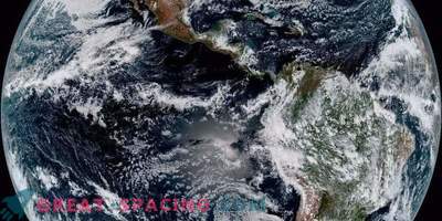
The first Earth observation satellite was launched on November 23, 1977. When the first Meteosat was established in the sky, it received an overview of the entire planet from the geostationary orbit and established the basis for European and global cooperation.
Weather affects human activity, so an overview of the entire Earth allows weather forecasters to track evolving meteorological systems. For example, the Atlantic hurricanes appear in the pictures of Meteosat before they begin to contact with the planet.
Prior to the launch of meteorological satellites, scientists could only rely on radiosondes, kites and airplanes. But the satellites provided a huge information array, which, together with computer models, made it possible to create forecasts for longer periods.
With Meteosat, some countries for the first time managed to analyze the ionosphere from space. The project originally belonged to France with the participation of CNES. But the European Space Research Organization (before ESA) also considered the possibility of using polar-orbital and geostationary satellites. The main office is located in Toulouse, from where it was possible to develop the project further.

To launch Meteosat-1, a Delta rocket from Cape Canaveral was used. It was established above the equator at 0 ° longitude. During the month, we registered all the systems and started receiving data used to create weather forecasts for many European countries. On November 23, 1977, Meteosat-1 was launched from Cape Canaveral and reached its operating orbit on December 7. The first shot arrived at the reception on December 9th. He became the first satellite in geostationary orbit, able to track the movement of moisture in the air.
The technology was more advanced, so the satellite could scan the entire earth disk in 30 minutes. Forty years have passed since launch, and scientists have been able to significantly improve weather forecasting. In addition, historical data allows you to track important climatic changes in the planet.
Of course, the first models were not intended for climate analysis, but their images show changes in soil cover and polar ice. There is also information about the temperature of the sea surface, which helped to create more accurate models.
The Eumetsat climate research satellite was launched only 10 years after Meteosat-1. Now in the position of 0 ° longitude there is always one functioning Meteosat. Scientists are developing a third generation of meteorological satellites that can guarantee a continuous overview of the atmosphere in the 2030s.
